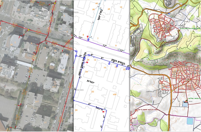
מערכת לניהול מוקד חם
Our Products
מערכת גיאומינד React4G מתאימה במיוחד למשרדים ממשלתיים רשויות ותאגידים הנדסיים שזקוקים ליישום פתרונות מיפוי אינטרקטיביים באתרי האינטרנט או ברשתות הפנימיות שלהם, תוך ניצול יכולותיו של טכנולוגיות מיקום לניהול ולהצגת נתנוים מרחביים
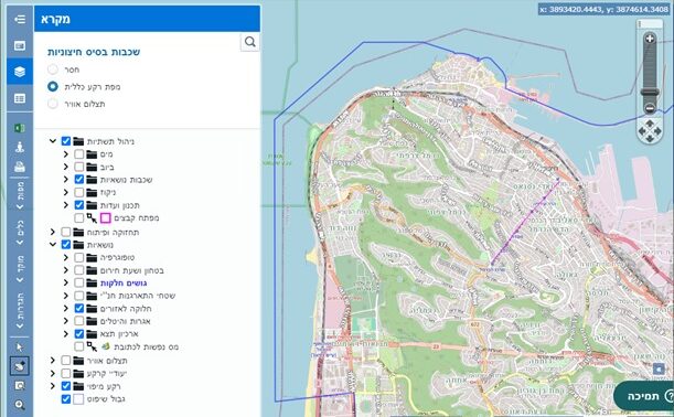
גיאומינד React4G
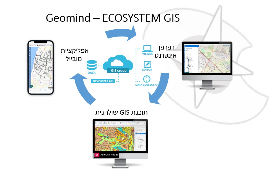
אפליקציית מיפוי אינטרנטית בטכנולוגייה מתקדמת. התוכנה עוצבה להתממשק עם שרתי קוד-פתוח מסוג MapServer, GeoServer, או שרתי GIS מסחרים אחרים, ומסקפת כלים ליצירה, צפייה ואינטרקציה עם נתונים גיאוגרפיים ומיפוי

תוכנה בטכנולוגיית React, להקמה מהירה של ממשקים, וחווית שימוש מתקדמת ודינמית.
תכונות עיקריות של גיאומינד React4G:
Key features of Geomind React4G include:
קוד פתוח: הפרויקט מסוג קוד פתוח, זמין לכל מי שמעוניין, ואינו מותנה ברכישת רשיונות.
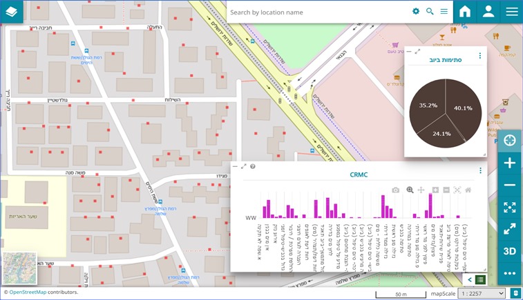
עשיר בתכונות: מציע מגוון רחב של פונקציונליות כגון שליטה בשכבות, הצגת נכסים, בחירת ישויות, ניווט במפה ועוד, שהם חיוניים למערכות מידע גאוגרפיות (GIS).
התאמה אישית והרחבה: מנגנון הרחבה של שכבות ומיידעים לפי הצרכים של המשתמשים.
ממשק זה מתאים במיוחד לארגונים שזקוקים ליישום פתרונות מיפוי אינטראקטיביים באתרי האינטרנט או ברשתות הפנימיות שלהם, לניהול ולהצגת נתונים מרחביים.

ניהול מידע תכנוני
כלים מתקדמים לניהול וקידום תהליכי תכנון, ייעודים ושימושי קרקע. כולל עדכונים בזמן אמת לצד מידע הסטורי והפקת דף מידע אודות זכויות בניה במגרש
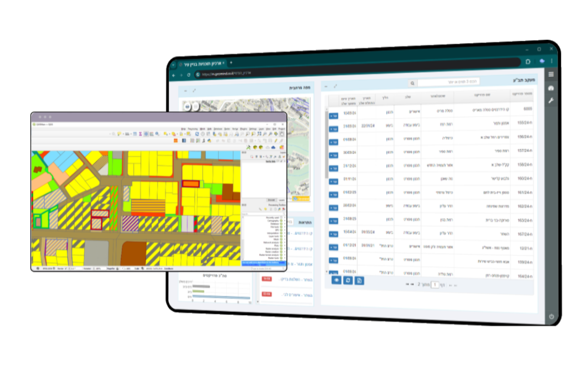
ארכיון תב"ע ויעודי קרקע
קידום הליך תכנון תבעו"ת והכלים לניתוח מגרשים ותצוגה ויזואלית של יעודי קרקע וזכויות בניה.
אנחנו נספק לכם את האמצעים לזיהוי אתגרים וקידום פתרונות יעילים, לתמיכה בקבלת החלטות ושקיפות ציבורית
הודעות Whatsapp
מנגנון תזכורות אוטומטי לתזכורות בדוא"ל, SMS או בווטסאפ.
ניהול פרויקטים
לניהול פרויקטים: מיפוי, ניתוח נתונים, תכנון וניהול תחומי, איתור משאבים, יישום תכניות וניטור פעולות

תוכנת ניהול נכסים כוללת מספר תכונות חשובות בכדי להקל על הניהול היומיומי של הנכסים ולשפר את יעילות העבודה,
בקידום ומעקב אחר הנכסים בצורה יעילה ואפקטיבית, ולשפר את השירותים שהיא מספקת לתושביה
1. ניהול נכסים ומתקנים – יכולת לרשום, לעקוב ולנהל את כל הנכסים העירוניים, כולל מבנים, פארקים, ורכוש קבוע.
2. מעקב אחר תחזוקה – יכולת לתכנן ולמעקב אחר פעולות תחזוקה רגילות וחירום, כולל תיקונים, בדיקות ושירותים תקופתיים.
3. ניהול פיננסי – אינטגרציה של פונקציות כמו תקציב, חשבונאות ודיווח כספי, תוך התחשבות בכל ההוצאות וההכנסות הקשורות לנכסים.
4. דיווח ואנליזה – יכולת ליצור דוחות מפורטים ולבצע אנליזה של נתונים כדי לשפר את התפעול ולתכנן אסטרטגיות עתידיות.
5. אבטחת מידע וגישה – מערכות אבטחה מתקדמות להגנה על מידע רגיש והגדרות גישה שונות לעובדים לפי רמות הרשאה.
6. ממשקים למערכות קיימות – אינטגרציה עם מערכות מידע עירוניות אחרות, כמו מערכות גבייה, מס הכנסה ותחבורה ציבורית.
7. ממשק משתמש ידידותי – ממשק נוח וידידותי למשתמש עם אפשרויות ניווט פשוטות ותמיכה בשפה העברית.
8. תמיכה טכנית ועדכונים – שירות תמיכה זמין ועדכונים קבועים לתוכנה כדי להבטיח שהיא עומדת ברמות האבטחה והתקנים החדשים ביותר.
9. ניהול חוזים ורישיונות – יכולת לנהל חוזים עם ספקים ורישיונות לשימוש במתקנים ובנכסים של העירייה.
10. תכנון ופיתוח עתידי – כלים לתכנון אסטרטגי של שימוש ופיתוח של נכסים עירוניים לאורך זמן.

תוכנת GIS לניהול תשתיות מים וביוב:
בקרה וקליטה אוטומטית של קבצי מדידה, שמירה על עדכניות המידע בסטנדרט הנדסי. אין צורך בהתמרה והסבה של מידע, ייבוא/יצוא מודלים ייעודיים לתאגידי מים כגון 'מגוף שולט', אחזקה, פרויקטים ויומני עבודה, אפליקציית מובייל לאיחזור וביצוע סקרים, עצמאות מלאה בתפעול מערכת ליצירת שכבות ועדכונם. הפקת מפות, דוחות, ביצוע שאילתות ועוד
עכשיו הזמן למהלך שלכם
הצטרפו היום ותגלו את גיאומינד
